geostationary satellite

What is a geostationary satellite?
A geostationary satellite is an Earth-orbiting satellite placed at an altitude of approximately 22,300 miles or 35,800 kilometers directly above the equator. These satellites revolve in the same direction the Earth rotates -- west to east.
The term geostationary comes from the fact that the satellite appears nearly stationary in the sky to a ground-based observer. These satellites complete one orbit in about 24 hours, which is the same amount of time it takes for the Earth to rotate once on its axis. The satellite appears to be stationary from the perspective of someone on the ground, as it moves in sync with the Earth's rotation.
Geostationary satellites are equipped with transponders that receive, amplify and retransmit radio signals to and from Earth. These signals can be used for a wide range of applications, including telecommunications, broadcasting, remote sensing and navigation.
How do geostationary satellites work?
A geostationary satellite maintains its position in space relative to the Earth's rotation using thrusters and reaction wheels. These tools let the satellite make small adjustments to its position as needed to keep its orbit at the same speed as the Earth's rotation and remain in the same position above the Earth's equator.
A satellite can achieve a 24-hour orbit only at the 22,300-mile altitude. This orbit keeps the geostationary satellite fixed -- or stationary -- over one longitude at the equator. It appears fixed in the sky to ground observers.
Before a satellite can be launched into a geostationary orbit, it's first launched into a transfer orbit. An orbit is the curved path that an object in space must take around another object, such as the Earth, because of the gravitational force of the other object. A transfer orbit is an elliptical orbit that enables a satellite to move to its final high-altitude orbit by using relatively little energy from built-in motors. Transfer orbits are used so that the satellite's launch vehicle doesn't need to go all the way to the its final altitude.
Coverage of geostationary satellites
A single geostationary satellite has a line of sight covering about one-third of the Earth's surface. In other words, it can "see" a third of the Earth's surface wherever it's positioned along the equator.
The satellite's orbit usually provides coverage from 20 degrees north latitude to 20 degrees south latitude. Three such satellites, each separated by 120 degrees of longitude, can provide coverage of the entire planet with the exception of small circular regions centered at the north and south geographic poles.
Advantages of geostationary satellites
Among the advantages of using geostationary satellites are the following:
- Reliability. These satellites are known for their predictable performance. This is why many U.S. telecom companies use them to provide backup capacity for their telephony services.
- Variety of services. They can support voice-, data- and video-based services for their designated region.
- Ease of use. A geostationary satellite can be accessed using a directional antenna, which is usually a small dish, aimed at the spot in the sky where the satellite appears to hover. These earthbound directional antennae can be aimed and then left in position without further adjustment.
- Minimal interference. The use of highly directional antennas minimizes interference from surface-based sources and other satellites.
- Navigational capabilities. These satellite systems can track objects on the ground with great accuracy using Global Positioning System (GPS) technology, making them ideal for navigational purposes.
- Global imaging. These satellites provide real-time images from space, making them useful for monitoring global climate patterns and other environmental changes.
- Long life. Geostationary satellite systems have long life spans compared with other types of orbital structures. They remain operational up to 15 years before needing to be replaced, whereas other orbiting equipment lasts five years or less.
Limitations of geostationary satellites
While geostationary satellites offer many advantages, they also come with disadvantages, such as the following:
- Limited numbers. The orbital zone for geostationary satellites in the plane of the equator is a narrow ring. As a result, only a limited number of satellites can be maintained in these orbits without the risk of conflicts or collisions.
- Latency. An electromagnetic signal travels a distance of at least 44,600 miles to and from a geostationary satellite, adding latency of at least 240 milliseconds. Such delays are a problem for services where low latency is required, such as long-distance voice and video conferencing. For this reason, geostationary satellites are best for applications where time delay is not an issue, such as direct TV services and internet data services.
- High cost. Geostationary satellites are more expensive to launch into orbit than other satellites because their high altitudes require more fuel and energy during takeoff. The distance can also make them more expensive to maintain over their life span.
- Limited coverage. Geosynchronous satellites can only cover a limited area of Earth's surface because they must remain stationary relative to one point on the planet's rotation axis. To extend coverage outside this area, other satellites must be added.
- Difficult to repair or replace. Because geosynchronous orbits are so far from Earth, the satellites can be difficult to repair or replace and can require specialized equipment.
- Disturbances. Satellites must be placed at a predetermined position and altitude to accomplish specific tasks. However, many disturbing forces and moments can make this difficult and require extra controls. For example, when a satellite comes near the sun, there can be a lot of background noise affecting its output. This "solar fade" effect is a problem within a few days of the equinoxes -- around March 20 and September 23 of each year. The disturbances last only for a few minutes and only once a day.
- Positioning. The exact position of geostationary satellites relative to the Earth's surface varies slightly over each 24-hour period because of gravitational interactions among the satellite, Earth, sun, moon and nonterrestrial planets. As observed from the surface, the satellite wanders within a rectangular region in the sky, which, although small, limits the sharpness of the directional pattern and the effectiveness of Earth-based antennas.
Applications of geostationary satellites
Geostationary satellites, with their 24-hour orbit and high elevation, have a range of applications, such as the following:
- Telecommunications. High-altitude satellites are used for long-distance and mobile phone communication and internet connectivity. For example, the Broadband Global Area Network uses geostationary satellites for global mobile communications.
- Broadcasting. Geostationary satellites are commonly used for broadcasting television and radio programming. TV signals can be relayed to viewers from a satellite in a fixed position above the Earth's equator directly to the viewer's location. Because of their high altitude, retransmitted signals can be picked up by a large area of the Earth's surface.
- Weather forecasting. Geostationary weather satellites provide real-time information about weather patterns and storm systems. For instance, the Geostationary Operational Environmental Satellite (GOES) series is a joint effort by the National Aeronautics and Space Administration and the National Oceanic and Atmospheric Administration (NOAA) to provide local weather warnings. The National Weather Service, which is part of NOAA, uses the GOES-18 to capture atmospheric measurements and real-time maps of lightning activity and to monitor space weather. The European Space Agency's Meteosat series of meteorological satellites is another example.
- Remote sensing. Geostationary satellites are outfitted with sensors to collect data and monitor events on the Earth's surface. For instance, they are used to study short-term oceanic and coastal phenomena, such as cross-shelf exchanges between seas and currents. They're also used to detect wildfires.
- Navigation. GPS and other navigation systems use geostationary satellite data to enhance their own accuracy. They use high-altitude satellites to provide a known calibration point for GPS receivers.
Low Earth orbit satellites vs. geostationary satellites
In recent years, low Earth orbit (LEO) satellite systems have become popular. These systems use a fleet or swarm of satellites, each in a polar orbit at an altitude of a few hundred kilometers. Unlike geostationary orbits, LEO satellites need not follow a particular fixed path around Earth. Rather, the LEO's plane can be tilted, so LEO satellites have more available routes compared to geostationary satellites.
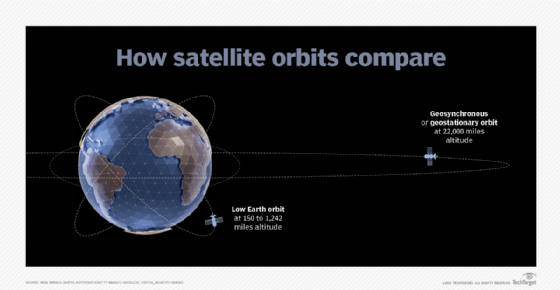
A LEO satellite's revolution around the Earth takes about 90 minutes; LEO satellites travel around the Earth about 16 times a day. And, since the satellites are in close proximity to the Earth, they can take higher-resolution images of the Earth's surface. These advantages make LEO satellites highly suitable for satellite imaging applications.
The satellites in a LEO swarm are strategically spaced so that, from any point on the Earth's surface, at least one satellite is always in line of sight. The satellites act as moving repeaters in a global cellular network. These systems support the use of simple, nondirectional antennas; offer reduced latency; and don't suffer from solar fade.
Find out more about the future of LEO satellite communications.
Continue Reading About geostationary satellite
Dig Deeper on Mobile infrastructure
-
![]()
Speedcast on board with connectivity for P&O maritime logistics
By: Joe O’Halloran
-
![]()
Hyperscalers use 5G to make an edge play into space
By: Amy DeCarlo
-
![]()
How low Earth orbit satellite networks improve internet access
By: John Burke
-
![]()
SES, Starlink claim cruise industry’s first integrated MEO-LEO service
By: Joe O’Halloran